Pikes Peak
Location: west of Colorado Springs, Colorado
Summit elevation: 14,115 feet
Easiest route: drive up/train
Date: August 28, 2013
Pikes Peak is in Colorado's Front Range and rises to the west of Colorado Springs. The peak can be accessed via different methods, including multiple trail routes that lead to the summit, but most people take one of two other options. The Manitou and Pike's Peak Railway is the highest railway in North America and begins in Manitou Springs and ends at the summit of the mountain. The Pikes Peak Highway is a 19-mile road that begins west of Colorado Springs in Cascade and ends at the summit as well.
I took the road to the summit because it was a bit cheaper than the train and I wanted to spend time as I wanted at the top and on my up and down. The road is now completely paved all the way to the summit (except for the parking lot at the summit). The road and summit were't as busy as I had expected, although I did visit on a Thursday and get stuck behind someone riding their brakes UP the last three miles of the road.
The road begins passing through forest and crosses the dam impounding Crystal Creek Reservoir where you get some of your first views of the peak. Before the road approaches treeline it passes the location of a former ski area and the Glen Cove Inn. As with most mountains in the west during the summer, it is best to go to the summit by around noon to avoid afternoon thunderstorms.
© Copyright 2017 Matthew Pintar. All rights reserved.
Summit elevation: 14,115 feet
Easiest route: drive up/train
Date: August 28, 2013
 |
| View northwest from the summit |
Pikes Peak is in Colorado's Front Range and rises to the west of Colorado Springs. The peak can be accessed via different methods, including multiple trail routes that lead to the summit, but most people take one of two other options. The Manitou and Pike's Peak Railway is the highest railway in North America and begins in Manitou Springs and ends at the summit of the mountain. The Pikes Peak Highway is a 19-mile road that begins west of Colorado Springs in Cascade and ends at the summit as well.
I took the road to the summit because it was a bit cheaper than the train and I wanted to spend time as I wanted at the top and on my up and down. The road is now completely paved all the way to the summit (except for the parking lot at the summit). The road and summit were't as busy as I had expected, although I did visit on a Thursday and get stuck behind someone riding their brakes UP the last three miles of the road.
 |
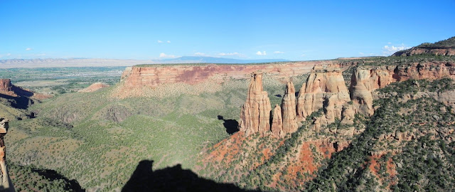
| Pikes Peak rises above Crystal Creek Reservoir |
The road begins passing through forest and crosses the dam impounding Crystal Creek Reservoir where you get some of your first views of the peak. Before the road approaches treeline it passes the location of a former ski area and the Glen Cove Inn. As with most mountains in the west during the summer, it is best to go to the summit by around noon to avoid afternoon thunderstorms.
 |
| View west |
 |
| View to the east |
 |
| Pikes Peak Highway nearing the summit |
 |
| Near the beginning of the highway above Cascade |
 |
| View north from below the summit |
© Copyright 2017 Matthew Pintar. All rights reserved.
Comments
Post a Comment