Congaree National Park
Location: east of Columbia, South Carolina
Date: December 31, 2013
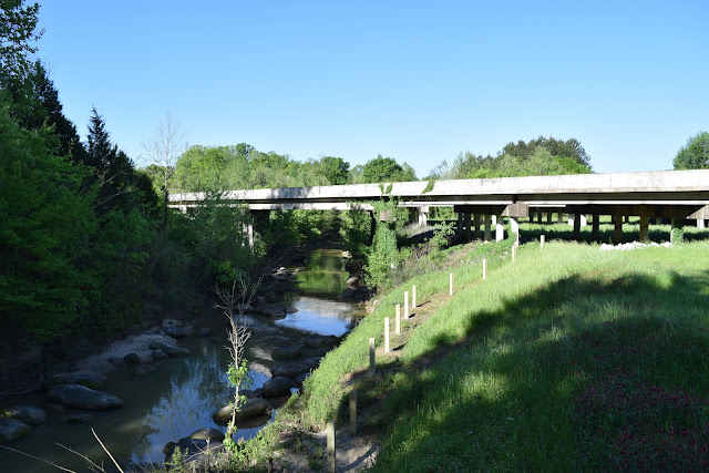
Congaree National Park protects the largest section of old-growth bottomland hardwood forest in the United States and is also a designated Ramsar wetland of international importance and a National Natural Landmark. The Congaree River forms the southern border of the park, but Cedar Creek and other streams cross the park as well. There are over 35 miles of trails in the park all of which can be accessed from the visitor center, but most people visit the 2.4 mile long boardwalk loop.
When I visited on the last day of 2013 the water levels in the Congaree River were so high that the forest was flooded up to four miles away near the visitor center. So, I was only able to walk across the elevated portion of the boardwalk to Weston Lake as an out and back hike (although it would have been a great day to canoe through the park). The other half of the boardwalk isn't elevated and was flooded. Other than a few birds, squirrels, and raccoon tracks, there wasn't much animal activity along the boardwalk, but many of the trees were quite impressive. Plus it was nice to see the park when I didn't have to worry about pesky mosquitoes.
© Copyright 2017 Matthew Pintar. All rights reserved.
Date: December 31, 2013
 |
| The flooded boardwalk |
Congaree National Park protects the largest section of old-growth bottomland hardwood forest in the United States and is also a designated Ramsar wetland of international importance and a National Natural Landmark. The Congaree River forms the southern border of the park, but Cedar Creek and other streams cross the park as well. There are over 35 miles of trails in the park all of which can be accessed from the visitor center, but most people visit the 2.4 mile long boardwalk loop.
When I visited on the last day of 2013 the water levels in the Congaree River were so high that the forest was flooded up to four miles away near the visitor center. So, I was only able to walk across the elevated portion of the boardwalk to Weston Lake as an out and back hike (although it would have been a great day to canoe through the park). The other half of the boardwalk isn't elevated and was flooded. Other than a few birds, squirrels, and raccoon tracks, there wasn't much animal activity along the boardwalk, but many of the trees were quite impressive. Plus it was nice to see the park when I didn't have to worry about pesky mosquitoes.
 |
| Weston Lake |
 |
| Flooded forest along the boardwalk |
 |
| Boardwalk |
 |
| Boardwalk |
© Copyright 2017 Matthew Pintar. All rights reserved.
Very Nice
ReplyDeleteWhat a nice place to explore the creation of Almighty God! I love nature and such kind of national parks are always the center of attraction for me. After reading this blog I wish to visit Congaree National Park in my upcoming summer vacations after my vegas helicopter tour. Let me know about any cheap nearer resort to stay there.
ReplyDelete