Payamatha Horse Trail
 |
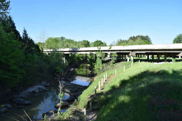
| About 1 mile of the Payamatha Horse Trail follows a gravel road, which appears to be along an old railroad grade |
The Payamatha Horse Trail is a 5.7-mile loop trail in Tombigbee National Forest southwest of Tupelo, Mississippi. The trail is lightly trafficked, especially by hikers, and is accessible from state highway 32, about 1.5 miles west of the Natchez Trace Parkway.
The trail begins by following a gated gravel road, and after about 0.25 mi the trail splits into a loop. The eastern side of the loop is entirely a standard hiking trail, whereas the west side of the loop is part hiking trail, part gravel road. In fact, the first ~1 mi portion of the trail that follows the road is quite flat and appears to have once been a railroad. The road section of the trail is the best maintained, widest, and easiest to follow.
 |
| The trail at the top of the hill in the logged area |
After a little over a mile (hiking counterclockwise) the gravel road becomes noticeably more overgrown, and the trail splits off to the left up the hill into a recently logged area. The trail through this logged area is very overgrown, but once you reach the top of the hill the trail enters the forest and isn't quite as overgrown. Over the about the next mile, the trail goes up and down a few hills and across one stream (plus several ditches that may or may not have water).
 |
| The trail through the forest |
Eventually the trail reaches road 116. If you continue west on the road for a couple hundred feet the trail continues south, connecting to the Witch Dance Horse Trail after a short distance. I opted to follow the road east for one-third of a mile to continue on the eastern side of the Payamatha Horse Trail and return to the trailhead. If you were to continue east on the road for another quarter of a mile, another trail would continue south, also connecting to the Witch Dance Horse Trail.
 |
| Road 116 |
The eastern side of the Payamatha Horse Trail was noticeably wetter and muddier from all the horse traffic than the western side. The scenery was largely the same - forest with small hills and valleys. Otherwise there wasn't anything notable about this trail until it returned to the trailhead.
More photos in this album.
See my track on AllTrails.
© Copyright 2017 Matthew Pintar. All rights reserved.
Get cash back credit cards through my referral links (we both get cash back bonuses):
Chase Freedom Unlimited
Discover It


Comments
Post a Comment